
by Dr. Lenore Tedesco, Executive Director
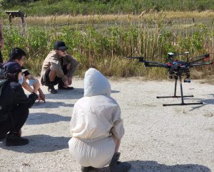
UPenn students prepare to launch a drone to capture high-resolution images of the marsh at TWI
More than 50 years ago, the founders of The Wetlands Institute preserved the vast coastal marshes that would later become the Cape May Wetlands Wildlife Management Area and deliberately built our campus in the heart of these wetlands. Their vision was to create a dynamic place where scientists and educators could work side-by-side to learn about these mysterious ecosystems, steward their protection, and educate others about their importance for our well-being. For more than 50 years, we have done just that.
Of course, that decision was made at a time when climate change was not at the forefront of our thinking and the concept of sea level rise was not a guiding principle demanding consideration in all we now do. My work, and the work of the scientists at The Wetlands Institute, is now dominated by studies to understand the marsh landscape around the Institute and its trajectory of change under the current and projected sea level rise scenarios we face. Closely coupled with the marsh change are studies of how the wildlife that depends on these marshes is responding. This work is foundational to the marsh restoration and habitat creation work we are doing with state and US Army Corp partners in the Seven Mile Island Innovation Lab, and will continue to take on an expanded scope and level of importance for the mission and longevity of The Wetlands Institute.
I have often written, including in this issue, of the work to protect and enhance marshes using clean dredged material at projects in the back bays behind Seven Mile Island. Our goal quite simply is to change the trajectory of degradation that these marshes face. We have now begun to evaluate the change happening on the Institute grounds and plan for the possibility of marsh enhancement projects on our property that can also help build protections for the Institute – as well as allow us to expand visitor services and research and education programs associated with the tools we are developing to move us all towards a more resilient and sustainable future.
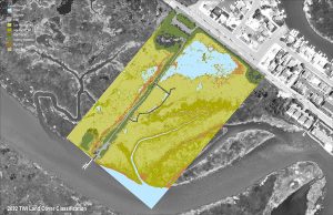
Map of marsh cover by type, created from drone photos
Our research scientists are using this newly acquired information to better understand marsh usage by diamondback terrapins and marsh nesting birds, and everyone at The Wetlands Institute is planning for how best to preserve and protect our treasured marsh resources. We are sharing our methods, results, and discoveries widely to enable the broader adoption and use of these tools over timeframes and scales that can make a difference. We’ll also be sharing our work in upcoming newsletters and lectures at the Institute in the coming months.